
Exciting Update April 20, 2018:
Vancouver has published their summary of the greenway here and has a more complete explanation of their implementation strategy and process here
Vancouver is developing some great unusual ideas about the future greenway. The Vancouver Sun ran an interesting article about the concepts here and the city of Vancouver has posted more details here, including a potential future streetcar.
Update Feb. 3, 2018: At the far western tip of Point Grey is UBC, the University of British Columbia. The Seattle Times has published an excellent article on its attractions at this link.
Update Nov 25, 2017: Vancouver is the only North American city without a freeway in its city limits. And now, 50% or more of all trips are totally by walking, biking, or using public transit.
Background to Vancouver's approach to transportation is at this link.
With the RSVP ride from Seattle to Vancouver coming up on Aug. 18-19, 2017 it’s a good time to check out Vancouver’s newest rail to trail paved greenway, the 9 km (5.5 miles) long Arbutus Greenway. http://vancouver.ca/streets-transportation/arbutus-greenway.aspx
The speed
with which Vancouver can install its facilities is phenomenal compared to
Seattle. In March 2016, after years of
fighting with Canadian Pacific Railways, the city bought the line. By June 2017 the city had completed a
temporary paved trail. They are
continuing to consult with the neighbors while the final trail and park is
designed with planned for construction beginning in 2019.
The Arbutus
Greenway is one of Vancouver’s city-wide network of connected protected bike lanes, bikeways,
and greenways routes connecting all parts of the city; see its cycling map at http://vancouver.ca/files/cov/map-cycling-vancouver.pdf (Below, the Arbutus Greenway is circled in red, the Off-Broadway Greenway circled in blue)

The quality
of the TEMPORARY Arbutus Greenway rivals the quality of many of Seattle’s permanent
trails. Like many of the facilities in
Vancouver, in many areas pedestrians and bikes are separated. Where pedestrians frequently cross zebra
striping is installed.


At most
street crossings there are stop signs on the roads that cross it; the bikes and
pedestrians have priority. At most of
the major street crossings the trail temporarily detours to nearby traffic
signals, but it’s planned that it will have its own signals in the future.


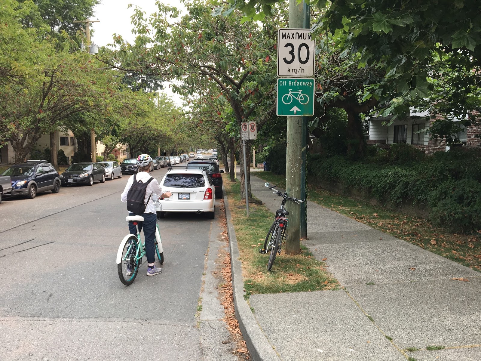
Calming Residential Streets
Off-Broadway Greenway
While
checking out the Arbutus Greenway, check out the Off-Broadway Greenway.
Broadway is a major east-west high-traffic arterial. It is paralleled a couple of blocks away by
the Off-Broadway Bikeway, on 7th and 8th. It’s a traffic-calmed residential street - traffic calmed to a much greater degree than greenways
in Seattle. It’s speed limit is 30 km/h (18.5 m/h). To prevent through vehicle traffic there are
right-in right-out concrete and landscaped vehicle diverters at many of the major cross-streets, and periodically cul-de-sacs have been inserted within its right-of-way.


Seaside Trail
Of course,
most visitors check out the network of PBL’s in downtown and the famous Seawall
and Seaside Trail.
http://www.letsgobiking.net/beginner/10-seaside-four-routes/
and https://averagejoecyclist.com/seaside-bike-route-vancouver-guide-video/
The Seaside
Trail begins downtown at the convention center, loops around Stanley Park
(warning: because of the volume of bike and pedestrian traffic, it’s one-way
for bikes in a counter-clockwise direction around Stanley Park), and then
follows Burrard Inlet and False Creek eastward to their end, then continues on
their south shore westward to Granville Island and on to Jericho Beach (where
there is a large hostel - http://hihostels.ca/en/destinations/british-columbia/hi-vancouver-jericho-beach
) and continues westward to Spanish Banks near the University of British
Columbia. (From its end , only at low tide, one can access Vancouver’s famous clothing-optional
Wreck Beach. http://wreckbeachcanada.com/trails.htm#From_Spanish_Banks_or_Jericho_Beach
)
The first parts of the Seaside Trail were built decades ago around Stanley Park and in the mid 70's along the south shore of False Creek. Lesson learned: At those times a mixed use promenade 12 to 18 feet wide was considered more than adequate. Since then the popularity of the trail has mushroomed, as have pedestrian-bicycle and bicycle-bicycle collisions. Most newer portions of the trail are much wider and separate pedestrians and bikes.
The first parts of the Seaside Trail were built decades ago around Stanley Park and in the mid 70's along the south shore of False Creek. Lesson learned: At those times a mixed use promenade 12 to 18 feet wide was considered more than adequate. Since then the popularity of the trail has mushroomed, as have pedestrian-bicycle and bicycle-bicycle collisions. Most newer portions of the trail are much wider and separate pedestrians and bikes.


Laurel Street Bridge
To get between the Seaside Trail and the Arbutus Greenway one can use the Laurel Street Bike and Pedestrian Bridge, thence the Off-Broadway Greenway west to the Arbutus Greenway.
The Laurel Street Bridge runs from the Seaside Trail at False Creek, somewhat east of Granville Island (it's not well signed - its right next to the Dog Park - use Google Earth to figure it). It runs across 2 roads (one 4 lane, one 2 lane) and a rail track and ends up at the Off-Broadway Greenway on 7th. When you're on the bridge, you won't notice it ... its heavily planted and is a place that mixes pedestrians and bikes well ... quite a different experience from Seattle's proposed Northgate Bridge.
 |
| Crossing the middle of the Laurel Street Bridge |
 |
| Laurel St. Bridge between South Shore of False Creek and the Off-Broadway Greenway on 7th |
Have fun in Vancouver ... there are days of biking explorations to do.
No comments:
Post a Comment
Note: Only a member of this blog may post a comment.