Continued from Part 2a - Introduction to Barcelona
Exploring El Born and Barri Gòtic
The previous chapter linked to this article that explained that the city had been hemmed in by the old city wall until 1854, when the Spanish government finally allowed the city to expand and the wall to be torn down. The city and its population had been growing, and as a result, the city became increasingly crowded and subjected to epidemics, the buildings became more dense, and open space more constrained.
Prior to going to the Picasso museum we wandered around the Old City getting fascinatingly lost in the maze of narrow roads. Imagine what it was like when the roads were crammed with people and horses pulling carts before the advent of modern sanitation.
Nowadays the maze is a blessing. Motor vehicle traffic is discouraged (but some is allowed with restrictions). Pedestrians rule the roads. Automobiles are the interlopers and proceed cautiously. Tourists enjoy the atmosphere, oblivious to what the atmosphere must have been like in prior centuries.
Nowadays people have found ways to replace parts of the roads with greenery, wider sidewalks, and comfortable plazas.to squeeze in some plazas. It's more delightful to eat outside now than 200 years ago.
Picasso - A Bookend
The Picasso museum in Barcelona formed a good bookend at the start of our trip, with art museums in Madrid at the end of our trip.
While many museums don't allow photography, several that we toured in Span, including the Picasso museum, allowed it. See the Picasso Museum's blog and an article in Art News about the issues involved. I took the following photographs in del Museu Picasso de Barcelona.
Even abstract artists need to understand the human body and many can draw and paint realistically.. Below is a photo taken in the museum of a study sketch Picasso drew as a student.
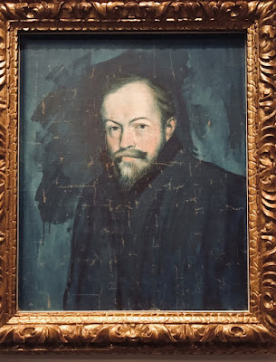
Throughout the late 1800's and early 1900's Picasso painted and sketched many portraits, much more realistically than I'd thought of his work - and all are very expressive of the personality. Unfortunately I only photographed one of them, but the Picasso museum website has lots of photos here.
Portrait of a friend, mentor, & patron of Picasso: Sebastià Junyet i Sans, 1903
I was particularly struck by one of Picasso's famous earlier abstracts from 1917: Gored Horse.
I got the same feeling when I saw his 1937 Guernica in Madrid.
Picasso's and Velázquez’s artwork by chance bookended our trip. Here in the Picasso museum was a display with an annotated photo of the original Velázquez’s Las Meninas with the real-life royal characters identified, together with a collection of some of Picasso's 58 (!) studies of it.
We later saw the original Velázquez at The Prado in Madrid at the end of our trip.
See the original on The Prado's website here, including short essays about it. It is one of the most important and discussed paintings in Spain.
See articles about Picaso's studies of Las Meninas from Noble Oceans and more extensively, from the Picasso museum . Articles like these add tremendous value, helping to bring life and interest to what could otherwise be a boring Museum walk-through. I'm not sure whether they are more helpful before or after the visit.
Las Meninas, August 17, 1957 Picasso's first painting in the series
Las Meninas, September 17, 1957 A study of a portion of Las Meninas
The Music Box
Palau de la Música by Domènech i Montaner is one of the highlights of many people's visit to Barcelona.
We stopped for a light lunch at the Palau's annex prior to our scheduled guided tour (the only way to see the inside other than attending a performance) for which we had bought timed tickets months in advance. The tour attendees all gathered in a corner of the annex coffee shop nearest the music hall's back stairways.
Usually I use Google Earth Street View pictures only when we didn't take a picture needed for the blog. But this picture also gives a chance to explain part of how we plan a trip. When planning a trip we almost always look at Google Earth Street View to (1) get a sense of where to find specific places and buildings and what they will look like - it helps us find them, (2) to scope out what the area is like around proposed hotels, and (3) most importantly, to develop a sense for the city.
The annex to the Palau de la Música photo from Google Earth Street View
The south corner of the front of the Palau de la Música

The exterior tile-encased columns near the entrance

The exterior tile-encased columns near the entrance
The stage and organ of the Palau de la Música:
The more you look at the details the more you see
The more you look at the details the more you see
The stained glass masterpiece skylight inspirits the hall and its ceiling.
On the last night we attended a concert. The hall is a much different experience at night; I'm glad we did both. But if I were to do only one, I'd definitely take one of the tours to see it in daylight and to hear the guides' explanation of the details..
The Cathedral
Roughly 2,000 years ago the Romans built their Temple of Jupiter near the center of Barcino, which eventually became Barcelona. See the map of Barcino here.
Throughout the entire time after the Roman Barcino fell to the Visigoths, who in turn were replaced by Muslims, who in turn fell to the Christians, that site of the Temple to Jupiter has remained a site of worship to various deities depending on who was ruling. During the entire time there was a continual succession of a variety of buildings of various configurations and styles.
"In summary, Barcelona Cathedral is a Gothic cathedral that has been renovated in the Neo-Gothic style, which was built over a Romanesque cathedral that was built over a cathedral that replaced a mosque (converted from a Cathedral that was upgraded from a church), which in turn was built over a temple dedicated to the main Roman God Jupiter." - From the website "The Legendary History of the Barcelona Cathedral" which condenses a very complex history into a short interesting read.
Befitting that complex history, the Cathedral of Barcelona is known by many names: as Cathedral of the Holy Cross and Saint Eulalia, or as Catedral de la Santa Creu i Santa Eulàlia, or as La Seu.
This post doesn't explain much about the early history, but it's a very easy to read summary of the history since 1298. This post explains a bit more.
Throughout the cathedral there are 140 side chapels devoted to saints (and others?)
mapped and itemized here. Like in many of the cathedrals and churches that we visited in Spain, the side chapels were extravagant, many gilded in gold (I suspect from the Spanish Americas.)
Saint Eulalia, for whom the cathedral is named and who is the patron saint of Barcelona, was perhaps a 13 year old Roman convert to Christianity, for which she is said to have been martyred. There is also a Saint Eulalia of Mérida. The accounts of the two saints are so similar some believe they reference the same person, others believe they are two distinct persons. Various accounts of her gruesome martyrdom differ in details and dwell on different aspects: (1) here (explaining her crypt and sarcophagus), or (2) here, addressing the 2 Eulalia's, or (3) here, or (4) here, or (5) here or (6) here, which ends on a light note: "Let’s make Eulalia great again and celebrate this weekend in a manner befitting her memory. Let’s lose all of our memories and roll down hills, outside of barrels, but maybe naked." (What? You didn't read all of the accounts? Good choice!)
Her bones are said to have been kept in one of the early churches, then in 711 hidden from the Moors when they invaded, subsequently rediscovered in 877, and are currently entombed in a crypt in the cathedral. (At least, that's what legend says - I can't accurately remember last month but her bones and their stories have been around for roughly 1,700 years.)


We had planned to visit the Barcelona history museum, which is just behind the cathedral, but it was getting late in the afternoon. Instead, we explored a bit more of El Born as we walked back to Plaça de Catalunya (which was a bit of a disappointment - I don't know what we expected) and then through Eixample back to our home and then to dinner.
Parc Güell
The next morning we got a late start and were in danger of missing our tickets' entrance time, so we hurried - the only time we used a cab on the trip except when arriving and leaving from airports or train stations.
Like most tourists, we headed straight for the Parc Güell Restricted Zone (Zona Regulada) for which you need tickets. That's the famous part - most people think of *it* as Parc Güell, but it's only roughly 7% of the park. Most of the park is a free, open park heavily planted with many native plants. On a future trip we would like to spend more time exploring it.
The Parc Güell website is extensive and informative. Of particular note, it describes Barcelona's general historical context here, the history of the park itself here, and has an overview drawing of the restricted area here. There is a collection of photos on another website beginning here and photos with more explanation here.
Below, Ginny is sitting on one of the very comfortable tiled benches overlooking Barcelona from the "nature square" above the hypostyle room. To shape its contours Gaudí had a worker sit in a plaster mold to form a comfortable shape.
One of the delights of a dry county: Notice the packed earth everyone is walking on. We noticed that througout Parc Güell and in parks throughout Spain
The Washerwoman's Viaduct - named because of a sculpture of a washerwoman on one of the pillars.
Gaudi's attention to imaginative details is evident in all of his work, such as his butterfly gate or the fence below..


We walked back through the upper entrance of the restricted zone (the tour bus entrance), thence down the road (Carrer de Ramiro de Maeztu) to the Alfons X Metro station. The road clings to a hillside with views over the upper reaches of the Grácia neighborhood. By this time we were in a hurry to get to the castell, so we didn't stop to take pictures. This Google Earth Street View will have to suffice:
Near the entrance to the Alfons X Metro station these guys were playing Pétanque in Parc de les Aigues
From Alfons X we took the Metro line L4 to Selva de Mar in the Poblenou neighborhood on our way to Parc del Centre det Poblenou to spend the afternoon at a Castell festival - a performance unique to Catalonia..
Castell Festival
The first time I was aware of Castells was when I saw this photo essay in The Atlantic. When we planned our trip I noticed that a Castell Festival was scheduled in Barcelona when we were to be there. We rearranged our entire time in Barcelona to accommodate it. It was a much smaller festival than that in The Atlantic, more like an informal local fair with refreshment vendors and picnics and people milling about with the castellers.
Catalonia's human towers, Castells, are summarized here, their 200-year old history is here, about their performances is here, and description of their elements is here.
I have two others videos of towers being built on youtube at here and here (double towers) - they were both too large to post here.
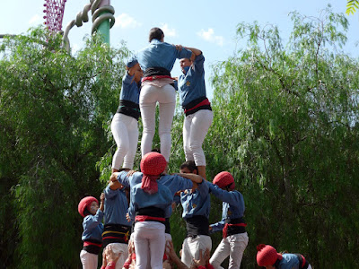
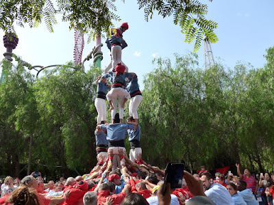
Below is my collection of photos of various of the day's towers.
First a scrum of people form a pinya; those in the center join hands to form a stable base.
Then the castellers climb on top of each other to form levels, called a tronc. The lowest level is stabilized by the hands and arms of the pinya.
.
The smallest and youngest (the only members wearing helmets) climb up the tower to form the pom de dalt and the enxaneta - the top.
The youngest and smallest, when reaching the top, raises their arm to crown the tower, then begins to climb down.
La Rambla del Poblenou and the Beach
From the Castells we wandered through Poblenou down La Rambla del Poblenou to the beach, thence home. Andre had already introduced us to a small part of this area during our bike tour the first day we were in Barcelona. We explored more on this day.
Poblenou used to be an industrial area which became increasingly abandoned and run down (see a short description here). The 1992 Olympics changed that. Barcelona's waterfront, previously derelict, was transformed into a 3 mile long beach running from the harbor to Poblenou and beyond.
A new Olympic village was built along the beach from roughly Citadel Park into the western portion of Poblenou. Like the Olympic Village built for the Winter Olympics in Vancouver Canada, it became a trendy and sought-after residential area. Urban renewal in other areas of Poblenou added new social housing helping to change the neighborhood from a post-industrial legacy.
Like in many cities, the slum areas of Poblenou offered cheap rents for artists, musicians, street people, and those living on the edge. But the lively folk living in edgy areas like that often result in the areas become hip, and once that happens, the areas often become "in". To me, it seems that Poblenou is going through that gentrification - it cuts both ways - for the better and for the worse.
Americans: Yep. That 10 means a speed limit of 10 kilometers per hour = 6 miles per hour. And the left hand side of the road is a 2 way bike lane. 😀
We enjoyed La Rambla del Poblenou much more than Barcelona's more famed La Rambla - it seemed much more intimate and neighborly. Also notice something that we found throughout Spain: almost invariably, when pedestrianizing a road one lane would be left open for motor vehicles to provide low-speed local access for people and deliveries (and for bikes).
La Rambla del Poblenou ends at the beach.
Even though we are not "beach people" we very much enjoyed walking back along the beach.
There was a wide paved promenade at the level of the beach and another above it at street level, and there were wide ramps between the two, perfect for bikes, hauling your beach accessories to the beach, and maintenance vehicles.
We stopped to relax on one of the benches where we ended up having a conversation with a guy. He was a student from Albania - a place that has always seemed mysterious to me. I love this cosmopolitan world we all inhabit, and hope that the new world that will develop after the contravirus doesn't change that, and that eventually nationalism retreats to the dark shadows again.

Another bookend: From the beachfront promenade we could see the Agbar Tower which is visible throughout Barcelona. It pokes its head up adjacent to the Plaça de les Glòries Catalanes, the important hub of 3 major boulevards. The Plaça is undergoing a major mega-project that demolished a huge roundabout of major elevated highways and is replacing it with an underground rail station, a park, and various public facilities. It will partially fulfill Cerdà's original plan for Eixample - to feature it as a major civic place. On our first day in Barcelona we explored part of the construction on our bike tour.
Walking back to our home in Eixample we walked through the Parc de la Ciutadella (Citadel Park) and along Passeig Luís Companys past the Arco de Triunfo de Barcelona, built as the main gateway for Barcelona's 1888 Universal Exposition.
What a long tiring day, but I guess we triumphed over it (in spite of our feet).
To return to Part 1 - Overview of our 30 days in Spain click here
For the next part: Barcelona - Part 2c - The Dessert click here.


No comments:
Post a Comment
Note: Only a member of this blog may post a comment.