continued from Barcelona - Part 2c - The Dessert
Reminder: click on pictures to enlarge themand follow links for additional information.
Some of the links are to Spanish-language sites when I couldn't find an English language site with similar information. If needed, use your browser's translation function.
 |
| from Google Earth |
This satellite view of Spain helps explain why the history of Spain is linked with the ebb and flow of European and Arabic cultures, and prior to that with the Roman Empire, and later, the Americas.
Granada: A Major Inflection Point in the World's History
In 711 the Moors arrived in Spain's Al-Andalus. They ruled Al-Andalus for over 750 years. That's over three times as long as the United States has existed as a nation!
Then came 1492: Within an astoundingly few months, the world changed. Drastically.
On January 2, 1492 the Emir of Granada, Mohammad XII, King Boabdil, surrendered the Alhambra and Granada to King Ferdinand and Queen Isabella. The last toe-hold of the 750 year-long rule of Al-Andalus by Islamic culture had finally succumbed to the centuries-long Reconquista of Spain.
The original surrender terms allowed Muslims to practice their religion unimpeded.
On March 31, 1492 Ferdinand and Isabella issued the Alhambra Decree: all Jewish were either to convert, or leave Spain. (See an account here.) The same choice was visited on the Muslims in 1502 and later, between 1602 and 1614 even the Muslims who had converted were forced to leave (See an account here). The purging of Jewish and Muslims is inseparable from the notorious 200 year long Spanish inquisition.
Christopher Columbus, who had spent years trying unsuccessfully to convince various monarchs to finance a voyage to find a new route to the orient, was in Granada when it fell. It is believed that during his time in both Granada and Cordoba he finally succeeded in convincing the royal court to finance his voyage.
On April 17, 1492 King Ferdinand and Queen Isabella signed a contract with Christopher Columbus (revised on April 30, 1492) that enabled his voyage that discovered the Americas.
On August 3, 1492 Columbus set sail from Seville.
Granada was so important to King Ferdinand and Queen Isabella that they decided to be buried there.
“… First of all, we ordain that in the Catholic
Church in the city of Granada a worthy Chapel shall be built, where, when it
pleases Our Lord to call us, our bodies shall be placed… “
- Royal Warrant of the Catholic Kings
 |
| By Olivier Bruchez from Wiki Media Commons under Creative Commons Attribution-Share Alike 2.0 Generic |
 |
| Spires of The Royal Chapel |
Except when we arrived at the airport and left at the train station, we unfortunately never had time to venture beyond the Old Town, and the even older Albaycín (where we stayed), and the Alhambra and its Generealife gardens. We walked to everything we needed; this part of Granada is by happenstance a 15 minute or 20 minute city that other cities nowadays aspire to.
Granada and The Alhambra are so well known and photographed that I'll concentrate more on other things we found interesting.
 |
Aerial view from Google Earth with annotations by me
|
1 = The Alhambra (on a hill over looking Granada)
2 = Generalife Gardens (on a spur ridge from the Alhambra)
3 = Cuesto del Rey Chico o de los Chinos (a path between Albaycín and the Alhambra)
4 = Paseo de los Tristes (Road of the Grieving & a plaza in the Darro River's valley)
5 = Apartamentos Turísticos Alhambra - Our apartment
6 = Mirador de San Nicolás - famed viewpoint, view of the Alhambra (especially at sunset)
7 = Plaza Nueva - The central plaza between the Old Town and the old Albaycín area
8 = Corral del Carbón - the only surviving Arabic caravanserai in Granada
9 = The Cathedral of Granada and the Royal Chapel
10 = The Puerta de las Pesas & Plaza Larga
11 = Mirador de San Cristóbal - viewpoint overlooking the Zirid citadel of the Albaycín
12 = Elvira Gate - a remnant from the old Zirid wall.
13 = Rail station
 |
Aerial view from Google Earth with annotations by me
|
Our Apartment & its Vicinity
We stayed at the Apartamentos Turísticos Alhambra in a studio apartment on the what Americans would call the second floor, or what Europeans would call the first floor.

A stairway led from the lobby up to two floors of rooms, passing by a portion of an 11th or 12th century wall around which the building had been built.


The stairway led past the two floors of rooms to a pleasant roof-top terrace with a stunning view of the Alhambra.

 |


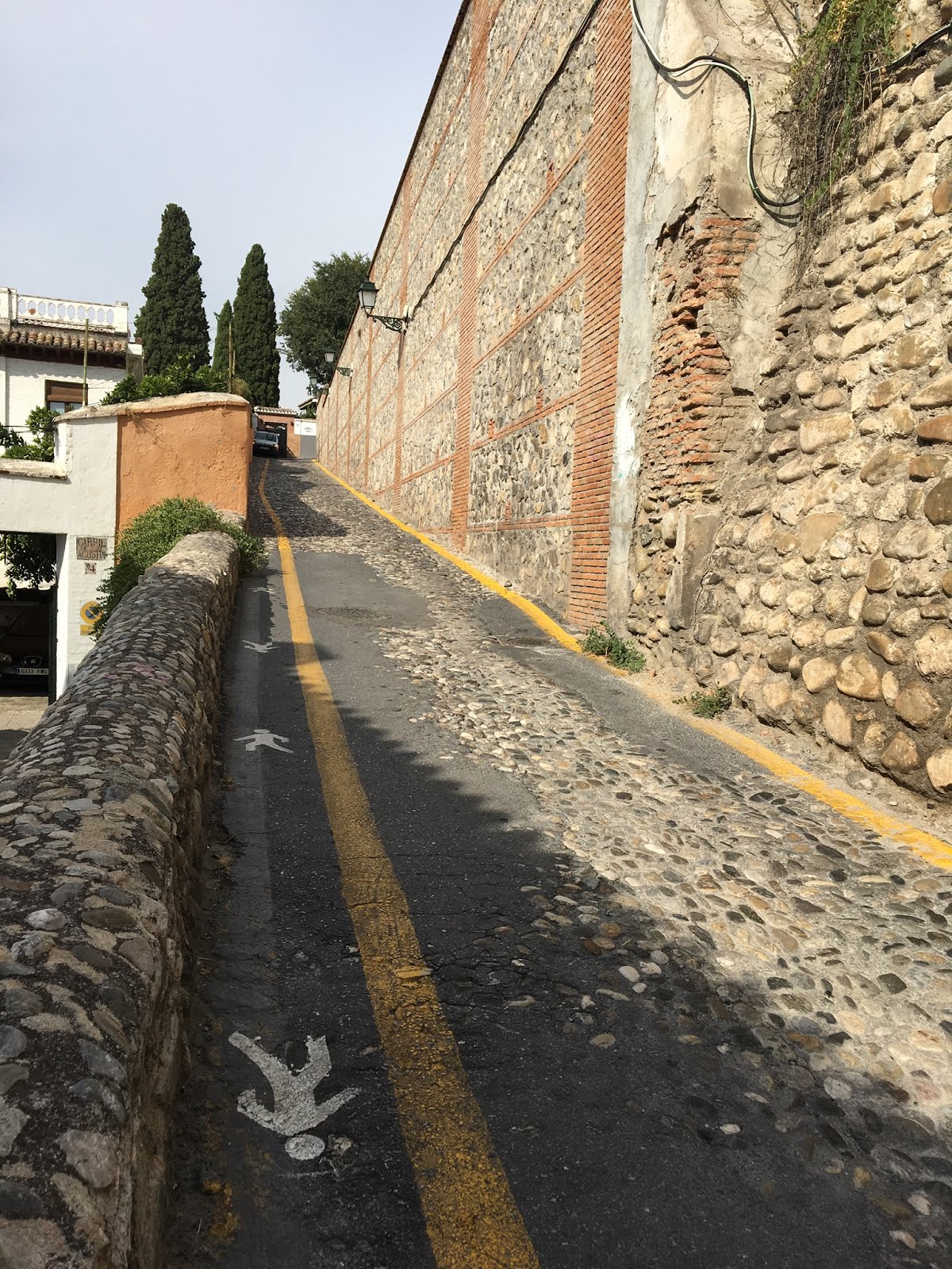
Our apartment (and the church) was located on the Calle San Juan de los Reyes (a street that dates from Roman times.). It is narrow. When we made reservations it was strongly suggested to have them arrange for a taxi - many larger taxis could not make it past some of its narrow, constricted jogs.
 |
| Entrance to Calle San Juan de los Reyes from the Cuesta del Chapiz |

The signs are meant to be read! 1.8 meters = 6 feet and 20 kph = 12 miles per hour.
The total length of Calle San Juan de los Reyes from its exit at Puerta Neuva near the Old Town from its entrance on the opposite side of the Albayzín off of the Cuesta del Chapiz is about 850 meters (1/2 of a mile).There are no other exits and there isn't any place to turn around.
When walking along it you keep an ear tuned. If you hear a motorcycle coming from behind, you scurry to the street's edge. If you hear a car you squeeze into the nearest wide spot, often just a recessed doorway.
One day when walking we encountered an Audi sedan (mid-sized by American standards, large by European standards) trying to back a long way to return to the entrance - its driver either didn't read the signs or didn't believe them.
You know about how people often photograph remote places, but neglect to photograph things near home? I plead guilty. I neglected to photograph just how narrow the street was in places, so I've used Google Earth's Street View to capture it. Notice that the narrowest part of the street is exactly where there is a jog in the street. From looks of the scrapes on the walls, auto paint shops in Granada must do a good business (or more likely, rental car agencies from their damage charges.)
 |
| From Google Earth Street View |
 |
| From Google Earth Street View |
The walkway below, the Calle Zafra, led from our apartment directly down the hill into the Darro River's valley.
On the right of this photo is the doorway to Casa Hernando de Zafra, one of the many homes of Zafra, secretary to King Ferdinand and Queen Isabella, who they made into one of the richest men in Spain.

At the bottom of the hill, near where Calle Zafra meets Carrera del Darro, Saints Peter and Paul stand above the entrance to their parish church, Iglesia de San Pedro y San Pablo. As part of the expunging of all that was not Christian, in 1501 in the Mosque of Los Baños (the Arabic baths were and remain nearby) first became a church, which then in 1559 was demolished and the current church built. Although plain on the outside the inside is of some interest.

The street Carrera del Darro, alongside the Darro River, is squeezed between the river and the buildings. It is the main clogged artery into the Albayzín from the Plaza Nueva. Pedestrians, taxis, motorbikes, buses, and the tourist bus-train that circles the Albayzín share the road.


The Old Town
The Plaza Nueva, created in 1835 after a major flood, is the central plaza between the Old Town and the old Albaycín area via the Carrera del Darro. A short one block walk brought us to to the Plaza Isabel la Catolíca from which Queen Isabel gazes up the Calle Gran Vie de Colón, connecting to Granada's central downtown.

From there we walked to another hinge between Moorish times and Catholic times: the Corral del Carbón, the only surviving Arabic caravanserai in Granada.

From there we wandered across the street to the Alcaiceria, the remnants of the 15th century silk market (most of it was destroyed by a fire in 1843).


We wandered into the Plaza de Bib-Rambla. According to Andalucia.com "No place is more emblematic of the 'Christian' part of the city. Surrounded by 19th Century town houses, shaded by leafy lime trees - and in the midst of a large pedestrian zone - the Plaza Bibarrambla is the real heart of the city´s social life."
The functions of the Moorish bazaar were still alive in the plaza in these modern times.
 |
| Twizzy |
The Cathedral
As we walked towards the Cathedral it wasn't hard to imagine what the Moors felt like with the looming presence of the Catholic Monarchs and their fervent, uncompromising religion.

The main mosque of Granada was leveled, to be replaced on its site by the Catholic Cathedral.
Strangely for such as important church, there is almost no consistency between the various blogs and sources that I consulted about the details and sequence of its early chronology. The best I can make out is that construction was authorized by the King and Queen and by the Pope during 1492. With the unexpected death of Queen Isabella in 1504 focus was changed to building the Capilla Real de Granada (the Royal Chapel). Construction began on the foundations of a Gothic-style cathedral in 1518 designed by the original architect, Enrique Egas. In the 1520's Diego of Siloam gradually became architect and changed the style to that popular in the Renaissance. It wasn't competed until 1704. If you include the two bell towers that were originally planned it is still not completed.
In spite of the inconsistencies in some of the details, explanations and photos are here, here, Wikipedia here, here, relationship with other Spanish cathedrals here, and a great essay on why to see both Seville's and Granada's cathedrals here.
It seems to me that the cathedral's Renaissance style expresses well the dominating and imposing tenor of those times.

The inside of the cathedral, reserved for the faithful, is resplendent. It bespeaks of the wealth of gold and silver flowing into Spain from its Americas during the 196 years of its construction.


The iconography in the cathedral matches Spain's view of the non-Christian world and its domination of the times, supported by the church.

With that image in mind, we retreated from the cathedral back to the Moorish Albaycin..
The Walls
One of the many fascinating (but often overlooked) things in Granada are the remains of its walls (remnants of which are even inside the Apartamentos Turísticos Alhambra where we stayed).
The original Moorish city in Granada, the Alcazaba Cadima, was on the highest point of what is now the Albaycin neighborhood. It was built on the remnants of the Roman city Eliberri. A large part of its walls and gates, the Zirid Wall, still stand including the Elvira gate and the wall between its Puerta de Manaita and its Puerto de Las Pesas. Although some of its remains are from the 8th century, most of it was built in the 11th century.
Later, during the Nasrid period in the 14th century, Granada had grown. Its much larger area was enclosed by the Nasrid Wall. Much more of it remains intact. It is easily seen when viewing Granada from the Alhambra.

Legend to maps above & below:
1 = The Cathedral
2 = Apartamentos Turísticos Alhambra - our apartment
3 = Plaza Aliatar & Centero Civico de Albaycin - neighborhood plaza & community center
4 = Mirador de San Cristóbal - viewpoint overlooking the Zirid citadel of the Albaycín
5 = Puerta Elvira - Elvira's Gate & Plaza - a local Granada blog about it here.
6 = Puerta de Manaita - one of the principal gates into Albaycín from the 11th Century
7 = Palace of Dar Al-horra - a palace dating from the Zirid period on the 11th Century
8 = Puerto de Las Pesas - a gate with earliest parts dating from the 8th Century
9 = Plaza Larga - popular plaza with restaurants and one-day a week market
10 = Mirador de San Nicolás - famed viewpoint, view of the Alhambra (especially at sunset)
 |
| Both above maps: Aerial views from Google Earth with annotations by me |
Many guidebooks say that you should enjoy wandering (and getting lost) in the many narrow picturesque winding streets of the Albaycín. We were forewarned. Trusting our instincts (supported only when absolutely necessary by both our paper and phone-based maps), we started wandering up the hill. The Alcazaba Cadima was at the top of the hill and the Zirid Wall is just beyond that. It should be easy to find. Right?
We started walking up enjoying our fascinating exploration.

We got glimpses of the Nasrid Wall to our right, on the hillsides near the Sacromonte district.

We kept continuing up
(After we returned from the trip, when looking at Google Earth satellite views, I noticed a break in the street pattern just where the Zirid Wall might reasonably have extended. I wonder if these more more modern walls were built along its route.)
Ah! Tourists! Let's follow where they came from. I didn't think a main road would lead to the top, but maybe it does.
We came to a nice plaza with an adjacent community center for the Albaycín.

It's a good place to stop for a bit, and maybe I can figure out where we are.
(We didn't know it at the time, but when home I found its location: # 3 on the above maps.)

Intrepidly, we kept walking.
Tour buses! Do we follow them to the left or the right?
(Later when looking at the enlarged photos, I realized that the motorcyclist seemed to be looking directly at my camera. Did we look that lost?)

Unexpectedly we came to a viewpoint crowded with tour groups. Later I found that this was the well-known Mirador (viewpoint) de San Cristóbal.

Finally I realized where we were. We had circled around the Alcazaba Cadima and passed beyond it. Unintentionally but fortunately, we had backtracked to this viewpoint overlooking its old Zirid walls and the city of Granada.


We wandered steeply down through the delightful neighborhood to the Zirid wall.


The Puerta de Manaita, is the westernmost tower and gate on the Zirid wall.


The gate was locked so we had to detour up the hill around it.

From the detour we could look steeply down to the Puerta Elvira - Elvira's Gate (see a local Granada blog about it here)

 |
| The Elvira Gate from Elvira Plaza - from Google Earth Street View |

Shortly we came to the Palace of Dar Al-horra - a palace dating from the 15th Century. Only very recently was a limited restoration done.


It had been the site of a pre-Roman Iberian burial ground, then was subsequently the forum for the Roman city Eliberri, then it became splendid gardens for Moorish royalty, then afterwards adapted as gardens for nearby convents, before being gradually neglected until the 1990's, when it assumed its current form. This history is summarized here.

We eventually made it to the easternmost gate and tower Puerto de Las Pesas - a gate with earliest parts dating from the 11th century but with a few 8th Century portions. Below it, tour groups swarmed in the Plaza Largo.

We got to the Plaza Largo at that awkward time in Spain when restaurants are often closed after lunch and before they open for dinner. Lunch in a restaurant's plaza was good (the beer was better) ... by the time we left the restaurant was starting to fill.

One our route back home we wandered across the top of Albaycín's hill and then down to the Mirador de San Nicolás which is mentioned in most of the guidebooks.

For us, it was a bit of an anticlimax, especially since the view of the Alhambra from our apartment's roof was as good. But the music of the musicians was good (turn on your speakers) and we took the obligatory photo of the Alhambra from the Mirador de San Nicolás .

To return to Part 1 - Overview of the Trip, click here.
For the next part, Part 3b - Granada: The Alhambra click here.
No comments:
Post a Comment
Note: Only a member of this blog may post a comment.